Saturday, July 16, 2011

Seven Devils Loop Run

Probably my favorite Idaho run.  The Seven Devils Loop is 30 miles of pure rugged alpine bliss.  My third time on this one and I still feel like it has my number.  I went Counter-Clockwise this run, but I have done it both ways.    A goal of 10 minute miles (5 hours total) sounds easy at home, but quickly deteriorates into exhausting 12 and 13 minute miles when the trail shows its devilish horns:  heat, rough trail, snow, downed trees, deep creek crossings, rerouting for obstacles, etc.  I drank 1.5 gallons of water out there and still lost 7 pounds.  This thing is a BEAST.


Windy Saddle Trailhead.  As pretty as trailheads get.  7500' elevation.

Coming down over the first pass the devil shows you his fangs: Devils Tooth spire.

Past the scenic Bernard Lakes, you encounter the most jaw-dropping view of the day from Dry Diggins Lookout 7850'.  

Looking North from Dry Diggins into Hell's Canyon.  Six-thousand plus feet straight down to the Snake River.  Deepest Canyon in North America.  It gets even deeper as measured from the top of the rim at He Devil Peak.  Over 8000' down to the Snake from there.  Amazing topography in Idaho.

Looking West from DDL.  The Wallowa Mountains of Oregon rise west of Hell's Canyon.

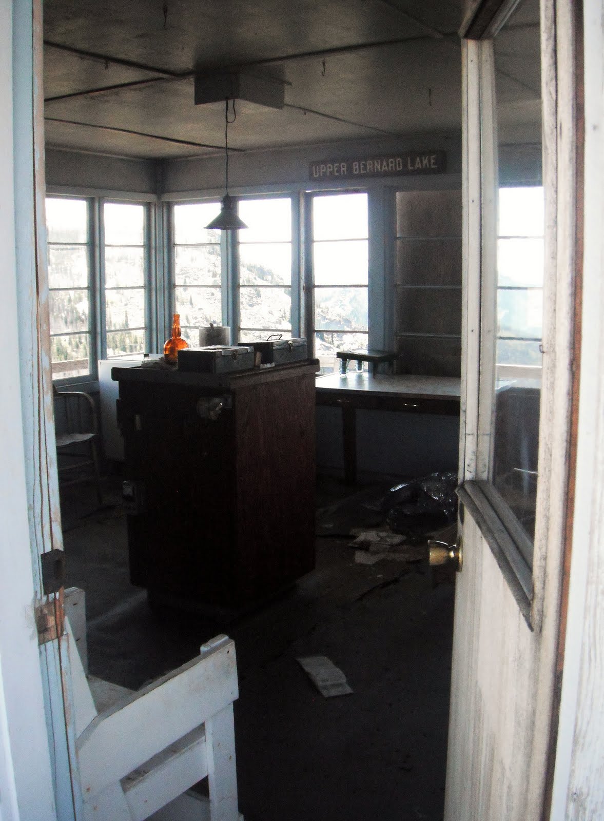
The shabby interior of DDL.  The door was open and the place is loaded with flies.  If this viewpoint was at the Grand Canyon, a milion people a year would visit.  But in the rugged heart of the Hell's Canyon Wilderness, 8 miles from the trailhead, I bet a few hundred would be a good year.  This national treasure needs some TLC.

 From the meadow near Hibbs Cow Camp.  The largest of the Seven Devils: Tower of Babel, He, She and the Ogre.

Somewhere on the Southwest side of the loop.  Perhaps Pyramid Mountain?

On the South side of the loop, looking South toward the upper reaches of the West Fork of Rapid River.  12 miles to go.

The remainder of the loop is still very scenic, but I managed no pics.  I was tired and locked in a full on war against the downed trees which are typical on the SE side of the loop in the early season.  One section had avalanched last winter and piled trees high over the trail.  Crawling through this section took patience.  Thankfully, soon after this section, I encountered a trail crew that informed me the next 9 miles to Windy Saddle TH were clear.  Home free.

Wednesday, July 13, 2011

East Fork Lake Fork

Quick out-and-back 15 miler.  Wanted to go over Snowslide Summit, but deep snow on the north facing slope slowed me down.  Got nice views of the Fitsum Summits and Nick Peak.  Lots of Elk track.


Monday, July 11, 2011

Crestline Trail Mega Loop

Really bad day to forget the camera.  I'm doing this one again in reverse soon.  It is among the best mountain runs I have ever done.  It had everything- long snow climbs, mud, river crossings, technical rock scrambling, sketchy trail and big commitment to finish.  There is some idyllic singletrack in there too.

The Route: Start at the Crestline TH off of Eastside Drive in McCall.  Climb steeply to 7100' to the junction of 108 and 109.  Make a right onto 108 and follow the nice trail to Fall Creek Saddle at 7850'.  Descend toward Lick Creek Road to the East, scrambling down steep granite ramps into a beautiful rocky cirque.  Pick up a trail that heads NE- angling left as you walk downhill.  A trail to Crystal Lake, popular among anglers, breaks off to the right, keep going on trail 108 to the TH on Lick Creek Road.

Head left (North) on LCR for about 1 mile to the Box Creek/ Black Lee TH.  Go left on Trail 110 and climb big time for 4 miles to a frozen col looking down on gigantic Box Lake.  Descend steep snow to the West (Left) shore and follow the shore to the lake's outlet on its NW corner.  The Trail continues heading NW to a cairned junction with the Crestline Trail.  Heading SW, I climbed a snowfield for 900 vertical feet to reach the crest. 

The trail on the crest was mostly obscured by the snow, so I just headed south, using occasional views of Jughandle Mountain for my bearing.  The terrain and scenery was spectacular.  As I lost some elevation a perfect ribbon of singletrack was exposed and I followed it for several miles passing Buck Lake and Squaw Lake and eventually reaching the trail junction near Blackwell Lake.  I made a right and finished the remaining 6 miles on familiar trail.  I had a cold soak in the creek at the bridge just before the trailhead, scubbing off the salt and grime.

The totals:  23.5 miles and 6500' of gain and loss.


Wednesday, July 6, 2011

Boulder Lakes Peak-Bagging Loop

Big vertical day with lots of bushwhacking and snow.  Had strong climbing gear and did plenty of uphill, off-trail running.  Awesome views and great weather.  This 14+ miler took me 3:20 to complete: a testament to its ruggedness.
  
Approaching Jughandle Mountain (8038') you arrive at the beautiful Louie Lake.

From Louie Lake, I climbed east and hit both Twin Peaks summits at around 8000'.  The view of Jug from North Twin summit.

From Twin Peaks, I bushwhacked North through the nice firm snow to Boulder Lake. This is the view from below its dam, looking East toward Buckhorn Mountain (8457').


From Boulder Lake, I climbed North to the summit of Boulder Mountain (8377').  From here I got a look North and East at the Shaw Twin Lakes (foreground) and behind them the Payette Lakes and McCall.


Looking North into the Lick Creek drainage.  Behemoth Slickrock is the tiny hunk of granite on the left edge of the photo.    Also visible (L to R) Snowslide Peak, Sawtooth Peak, Fitsum Peak and Nick Peak- all 8000-9000 footers.


Running the ridge east of Boulder Peak.
  
One last look back at the Jughandle massif with the Twin Peaks in the foreground.

Big climbin'
4300+' of gain and loss


Wednesday, June 29, 2011

Payette Rim Trail 6/27/2011

Been trying to figure out the "official" PRT since moving to McCall.  I think we got it down after today.  We spent an hour or so off-route and bushwacking in the snow.  It was fun and added spice and adventure.

Elk calf left behind by its mother. 


Two hours later and the calf is still there.  I called the wildlife sanctuary to see if they would take it in.  They told me that a mother elk will leave its calves for up to 4 hours while she feeds in the higher meadows, before returning to nurse the calf.  Calves have 2 special adaptations for this survival strategy: they have spots to stay hidden and they are scentless to predators.  I returned the next day and the calf was gone and fresh tracks of mother and baby disappeared up the hill.  Whew!


The gorgeous views of the PRT.


Lake Tahoe???  Nope, it's Payette Lake in McCall.


A little offroute here, we picked up a snowmobile trail and looped back around to join the PRT.


BRB on nicely packed snowmobile crust.  Still 2-3 feet deep at 6500' altitude.


Sunday, June 26, 2011

Wild Rockies 10 Mile Trail Race: McCall, ID 6/25/2011

http://www.spondoro.com/results/JugMtnRanchXCRun/2011/results.pdf
(bike race results listed first, scroll to bottom of .pdf doc for foot race results)

Pre-race Lead-up:  Ran some tough hills the past few weeks in Colorado and Idaho and felt pretty fit cardio wise coming in to this one.  I was a bit worried about a run I had done earlier in the week covering 22 miles, with 9 of those on snow and some big climbing.  I rested for 2 days pre-race and decided to enter the race the day before. 

The run started behind the Jug Mountain Ranch Clubhouse with a gently uphill jeep road and soon got steeper. I began quickly and took the lead within a minute.  By 1.5 miles, I had left the early leader, Daryl, but was caught by my strongest competition for the day, Kevin.  He lead for about a mile, but I overtook him on the first real downhill of the day at mile 4.  I made a note of this and decided to reserve some strength on the ups and flats, then try to make gaps on the downs.  This makes a challenger work harder to close gaps when the running is harder- on the flats and ups.  Usually, my strategy is opposite of this; I prefer to dominate the climbs.  However, I really had no climbing legs after mile 3 or 4 from my long run earlier in the week.  So, I decided to go for it on the downs.

Kevin caught me again and we ran across the flattest section of the course together, crossing the dams of the two reservoirs and getting wet and muddy as we chatted some.  Each time I made a move, Kevin answered.  Kevin hung right with me past mile 6 as I began to worry about my endurance.  My legs were tightening and I was unsure if I could keep this furious pace.  Not sure what happened, but there was no Mile 6 aid station as promised.  I took a glance back and could see some daylight as I tore down the jeep trail at top speed.  I did get to the Mile 7 aid station (mile 7.5-ish), just as it was being set up.  A young kid poured a quick 1/2 cup of gatorade stuff and handed it to me as I ran past.  I got a third of it in my mouth, but it helped.  I had planned to eat a gel here that I was carrying, but I did not have the time to drink the fluid that would be needed to wash it down.

The final sustained climb loomed and I hit it as hard as I could.  Lots of rocks and obstacles kept the pace slow but steady.  I stole another look back and I caught sight of Kevin a few switchback behind.  I hit the top and was tired of being chased, so I decided to end it on that downhill.  I opened my stride, began pumping my arms while driving downhill and leaping granite boulders and mud pits.  The pain and fatigue subsided and I just ran like a maniac.  I smiled big and thought of GLH.  He would have enjoyed the intensity of that section. 

At the bottom of the climb, the course rolled over some small meadows and the golf course came into view- signaling the end was near.  I caught another look back in one open meadow and saw no one, so I reminded myself to run my own race, stop worrying and have fun out there.  Soon, the finish line came into view and I sprinted with my remaining strength, crossing under the arch in 1 hour and 7 minutes. 

I had a nice time out there, running some trails I knew from training days and some new ones. The course was good mix of fast and slow with no real sustained bits.  It kept changing and kept me on my toes throughout.  I wished B had come out, but she had Farmer's Market sales to make and a bum knee.  They made me stand on a podium for my award, which I had not done since 7th grade.  I drank a little beer with my recovery snacks and headed home to watch the live Western States 100 feed on the internet.  Nerd.

Sunday, June 5, 2011

Rapid River West Fork

Big training run with huge altitude gain: 9000' over 25.2 miles.  Felt strong just 1 week after Pocatello.  103 miles in the last 8 days!

Few miles from the TH, the trail climbs above the rocky cliffs and roaring river

8 miles from the trailhead (4200'), looking down on the McRea Cabin from the nice meadow above.


Inside the rustic cabin.  Camping is allowed here.  Really cool place.


The only elk I spied on my run.

The prized morel mushroom.  If I had a garbage bag, I could have filled it.  Instead, I stuffed my shorts and made it to the McRea Cabin and got some ziplocks to carry them.  In all, I toted them for 10 miles down the trail.


Bushwack section through a burned out area at miles 10-12 cut me up pretty nice.  Notice the black ash on my legs.

The bounty on the cutting board at home.  Delicious with my breakfast eggs.